We are helping to enhance Colorado's watersheds and water quality by providing
CDSN's data partners and Colorado's citizens with an accessible and affordable tool kit
for data management, data analysis, and data sharing.
GEOSPATIAL ANALYSIS OF CDSN, USGS & EPA MONITORING SITES AND GIS DATA EXTRACTION.
All CDSN monitoring locations and supporting GIS baselayers will be updated between mid-April and May, 2019. The current GIS layers and applications incorporated the Colorado Department of Public Health & Environment (CDPHE) Water Quality Control Division (WQCD) 2016 Integrated Water Quality Monitoring and Assessment Report and Colorado's Section 305(b) Report. The April-May 2019 GIS updates will incorporate CDPHE WQCD's fall 2018 publication of the 2018 Integrated Water Quality Monitoring Assessment Report, 2018 Colorado 303(d) List, and Monitoring and Evaluation List and accompanying GIS data. It will also incorporate the latest USGS and EPA baselayers, and updated CDSN monitoring locations added or modified between November 2016 and April 2019.
All CDSN monitoring locations and supporting GIS baselayers will be updated between mid-April and May, 2019. The current GIS layers and applications incorporated the Colorado Department of Public Health & Environment (CDPHE) Water Quality Control Division (WQCD) 2016 Integrated Water Quality Monitoring and Assessment Report and Colorado's Section 305(b) Report. The April-May 2019 GIS updates will incorporate CDPHE WQCD's fall 2018 publication of the 2018 Integrated Water Quality Monitoring Assessment Report, 2018 Colorado 303(d) List, and Monitoring and Evaluation List and accompanying GIS data. It will also incorporate the latest USGS and EPA baselayers, and updated CDSN monitoring locations added or modified between November 2016 and April 2019.
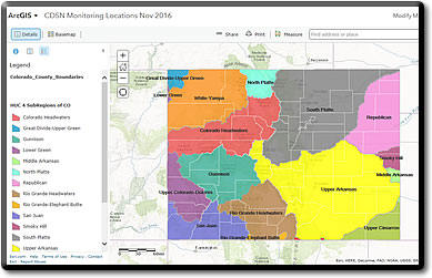
The CDSN Web GIS utility concept was developed in collaboration with Colorado Department of Health and Environment, and U.S. Environmental Protection Agency, Region 8. The purpose of the CDSN Web GIS is to allow for simple GIS queries to be made on CDSN monitoring locations managed in AWQMS and allow for determining geospatial relationships to impaired waters, HUC 8 and HUC 12 codes, ecoregions, waterbody ID, and basins.
This GIS application and its data layers were created by CDSN in cooperation with Water Quality Control Division, EPA, and USGS. While we used the best available data in our November 2016, we do not guarantee accuracy of data. Please contact the CDPHE Water Quality Control Division (WQCD) for plan revisions and updates https://www.colorado.gov/pacific/cdphe/wqcc-reports-and-plans and updates to WQCC GIS source data https://www.colorado.gov/pacific/cdphe/clean-water-gis-maps. Metadata, links to original data sources and GIS downloads are available on the tabs above.
On the GIS download tab above, CDSN also makes available GIS files for download and use in your own desktop GIS. We anticipate updating our Monitoring Location shapefiles as resources are available.
The CDSN Web GIS Application lets anyone perform basic geo-spatial queries from the online utility. More advanced functions, including using the application in your own desktop GIS environment are available--just see the quick start guides. There are two CDSN-created quick start guides on the application tab, one for those WITH an ESRI ArcGIS Online user account and one for those WITHOUT one. See below for information on how to create a free ESRI Online user account.
CDSN Web GIS Utility allows users to do simple to advanced GIS operations between AWQMS monitoring locations and useful baselayers such as the National Hydrography Dataset (NHD), 8- and 12-digit Hydrologic Unit Codes, EcoRegion III and IV codes; and elements of the CDPHE/WQCD Integrated Water Quality Monitoring and Assessment Report such as 305(b) and 303(d) impaired waters GIS layers. Users can quickly gain additional metadata about AWQMS monitoring locations via pop-up metadata boxes and can also download GIS files (see the download tab) for use in your own desktop GIS system.
This GIS map application and its data layers were created, modified or obtained by CDSN in cooperation with Water Quality Control Division, EPA, and USGS. While we used the best available data in our November 2016, we do not guarantee accuracy of data. Please contact the CDPHE Water Quality Control Division (WQCD) for revisions and updates of their programmatic and regulatory data layers.
 CDSN GIS Applications & Geospatial Data Layers.